We propose to conduct the survey at the Apache Point Observatory (APO) on Sacramento Peak in New Mexico, a site which meets all of the requirements and most of the desiderata of the SDSS. The site is on the continental U.S., is well-developed and is readily accessible. The weather, seeing and sky brightness at this site are excellent, as necessary for the successful conduct of the SDSS in our lifetimes. Three of the SDSS institutions (Chicago, Princeton and Washington) have been involved, through their membership in the Astrophysical Research Consortium (ARC), in the development of this site, which has already in place the support infrastructure needed to run the survey and has a Forest-Service approved place to build the 2.5 m telescope.
Several major redshift surveys, including the SDSS, are currently planned or are underway. Most of these are to be conducted in the Southern hemisphere, and the comparison of the results of these surveys with those of the Northern hemisphere SDSS will greatly enhance the value of both sets of surveys. There are at present no ongoing or planned redshift surveys in the Northern hemisphere which are at all comparable with the SDSS in terms of angular coverage or number of redshifts to be obtained.
The technological challenge of the camera and the data system, and the drilling of the spectroscopic fiber plug plates, all mandate location of the SDSS at a site easily accessible for the member institutions. Location of the survey at APO makes it logistically possible to carry out the major part of the data reduction at Fermilab. We also hope to be able to handle the transfer of data products to the SDSS member institutions over the Internet or its successor by the time the survey is underway, and this may not be possible from a more remote site.

Contour map of the site. The Apache Point area and the Sacramento Peak Solar Observatory are shown.
The APO site lies in the Sacramento Mountains of south-central New Mexico within the Lincoln National Forest, and is about half a mile south of the Sacramento Peak station of the National Solar Observatory. The latitude and longitude are 32° 46' 50" N, and 105° 49' 12" W, and the elevation is about 9180 feet (2800 meters). A map of the site area is shown in Figure 3.1, and includes the locations of the Cosmic Ray Site, the National Solar Observatory, and the roads in the area. APO is located on a promontory which projects westward from the main ridgeline.
The summit area itself is fairly flat, gently sloping, and lightly wooded.
Since the main ridgeline is the western boundary of the Sacramento Mountains, only low foothills lie between Apache Point and the Tularosa Basin, 10 km to the west.
The prevailing winds for most of the year encounter the Apache Point Site as the first obstacle, and there are thus no upwind sources of turbulence or warm air. The turbulent boundary layer is locally quite thin.
Access to the observatory site is necessarily from the east since deep and steep-walled canyons bound the promontory in the other directions. An 1800-meter paved road connecting to State Highway 6563 has been in place for several years to provide access to the ARC 3.5 m telescope.
Early planning by the Astrophysical Research Consortium, in consultation with the U.S. Forest Service, allocated two sites for major telescopes at Apache Point in addition to the 3.5-m site, where development is complete. The Board of the Astrophysical Research Consortium has undertaken the management of the construction phase at Apache Point for the SDSS, and the subsequent conduct of the SDSS, using one of these two sites.
In addition to the telescope itself, there is SDSS supporting construction needed at the site, but ample space for these associated activities is available. Consequently, in August 1992, after soliciting proposals from a number of highly qualified design firms, M3 Engineering and Technology of Tucson, Arizona was selected to provide design services for the necessary new developments at the site to accommodate the SDSS. M3 Engineering has extensive experience in the design of astronomical observatories in the southwestern United States and completed the design for the new survey facilities in February 1993. Construction was completed that same year.
The development for the 3.5-m site includes the telescope enclosure, an operations building, a utility building and a dormitory (Figure 3.2). The operations building contains 350 m² (3700 ft² ) of floor area and includes a computer room, electronics shop, darkroom, kitchen, lounge and library. The SDSS will be able to share many of these facilities. In particular, the present computer room contains adequate space for the needs of both telescopes. About 132 m² (1424 ft² ) of floor area was added to the operations building. The existing library and electronics shop were moved to this addition. The space thereby vacated will be used in support of the survey as a control room and workshop. Also, three new offices were added for survey personnel and the original darkroom was remodeled for use as a clean room for servicing the CCD camera.

Site plan for the SDSS project. The 2.5 meter telescope building, the plugging support building (all shown cross-hatched) and operations building (new addition shown cross-hatched) are shown. The new dormitory building (cross-hatched) is at the upper left.
The utility building contains a two-car garage and a 50 m² (500 ft² ) machine shop.
The original dormitory consists of three motel-type rooms, each with two beds. A second dormitory was added about 30 meters east of the existing dormitory, and contains six single rooms and a kitchen.
The 2.5-m telescope is located about 90 meters (300 feet) south of the 3.5-m telescope enclosure. The site is 20 meters (70 feet) west-southwest of the ridge top. The 2.5-m support building is near the telescope just beyond the open position of the telescope enclosure. Its main function is to provide a space for the plugging of plug-plates and for the storage of plug-plate cartridges in the plugging queue or the telescope queue. Inevitably, some telescope and instrument maintenance will occur in the support building because of its proximity to the telescope.
Near the 2.5-m support building is the Monitor Telescope enclosure (see Chapter 5). Since this telescope does not require excellent image quality, it is located near the support building for maximum convenience and sheltered in a small commercial dome.
A driveway links the 2.5-m telescope with the rest of the site. It is used to deliver the plug-plates to the support building, to supply consumables and for the occasional removal of the primary mirror for realuminization. This driveway is not paved so that the heat storage and absorption characteristics of the soil near the telescope are not degraded. Sidewalks connect the support building to the operations building and the lower parking lot, and provide access for people and wheeled carts.
As part of the same construction contract, a 1.0-m telescope enclosure was built for New Mexico State University (NMSU). Under an agreement with NMSU, ARC is providing a telescope site and some services and facilities to NMSU. The terms of the agreement provide that NMSU pay its share of all costs associated with construction and operation of the telescope and that management and funding is independent of ARC. The 1.0-m telescope site is located between the 3.5-m and monitor telescope sites. A 30 meter high tower which supports microthermal sensors and wind speed and direction indicators is located 60 meters (200 feet) south of the support building.
We have not made significant changes or additions to the other infrastructure at the site. These facilities include a 185 kVA emergency power backup generator and a 20,000 gallon water storage tank and 500 gpm pump for fire protection. Electrical power comes to the site via overhead 3-phase conductors with a grounded counterpoise for lightning protection. These conductors are owned and maintained by Otero County Electrical Cooperative. Domestic water is supplied to the site from wells belonging to the National Solar Observatory (NSO), for which ARC is charged at local Cloudcroft rates.
US West provides 25 phone lines to the site. We currently have four voice lines for general communications, one line dedicated to FAX service, two lines dedicated to modem use, and 1 circuit dedicated to a leased T1 (1.544 Mbit/second) line to Las Cruces, New Mexico for Internet access. These lines come from a microwave tower through NSO to APO, at APO expense. White Sands Missile Range has 1 voice circuit and 4 data circuits. There are three new circuits currently awaiting installation.
The Apache Point climate is relatively mild, particularly considering its 2800 meter elevation. Winds strong enough to interfere with normal observatory operations are relatively rare and are, in any case, often associated with thunderstorms. Rarely should access to the observatory site be impaired by heavy snowfall.
The weather patterns at APO are similar to those at Kitt Peak, though the summer `monsoon' is not quite so severe. At KPNO, from 1966 through 1986 67% of the nights were useful, and perhaps about half of these were photometric. Similar statistics apply to Apache Point. These statistics confirm the results of other studies of cloud cover made over the past 30 years.
Over a year, 70% of the night time is clear, best in October-November ( >85 %) and worst in July-August (50-60%). The percentage of nights that remain perfectly cloudless and photometric throughout the night averages about 35% (50% in October-November, <19% in July-August). These numbers are comparable to or better than optical sites at Mt. Hamilton, Mt. Palomar, Mt. Wilson (California), Kitt Peak (Arizona), and Mt. Locke (Texas) (Smith and Salisbury 1962).
The precipitable water vapor should be as low as possible because of the effect of water absorption on i' - and z' -band photometry and spectrophotometry near the long-wavelength limit of the spectrographs. This quantity ranges from less than 2 mm to 5 mm seasonally, and is as low as any major continental observing site except Mt. Lemmon (Arizona), as would be expected at an altitude of 2800 meters.

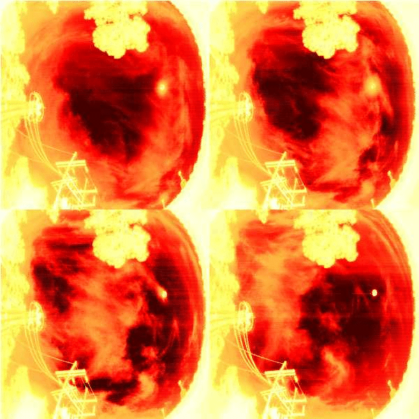
Four images of daytime cloud cover at APO. The observations are taken four minutes apart by the 10 µm cloud scanner. The cloud motion from WSW can be seen. The brightest feature, above and to the right of center, is the Sun.
Since early 1994, an imaging cloud scanner (Hull et al. 1995) has been in operation at the site to provide rapid, reliable, quantitative measures of cloud cover. This scanner uses a liquid-nitrogen cooled HgCdTe infrared detector which maps the sky over a 135°x135° area centered on the zenith every ten minutes with an angular resolution of 0.9°. The scanner operates at 10 µm and is highly sensitive to emission from clouds. An example of four daytime images is shown in Figure 3.3. The cloud motion can be seen, as can the scattering of sunlight, which enlarges the solar image, as clouds cross the Sun. The emission measured by the cloud scanner can now be accessed by the Monitor Telescope data reduction software (see Chapter 5). Data are now being gathered for a study of the correlation between atmospheric extinction measured by the MT and 10 µm emission measured by the cloud scanner.
The average visual sky brightness (Schneeberger et al. 1979) is 21.9 V mag per square arcsecond, not including the darker, midwinter nights (December-February). The site is protected from growth in light pollution by White Sands Missile Range and National Monument to the west, the Lincoln National Forest to the east, the Mescalero Apache Reservation to the north, and the Fort Bliss Military Reservation to the south. The growth of nearby Alamogordo is expected to be limited by availability of water; in any case, the City of Alamogordo in 1990 passed a lighting ordinance, very favorable to astronomy, which controls the types of lighting which can be used in public places and places strict control on lighting after 11:00 PM. In 1978, El Paso and Alamogordo contributed 10% of the sky brightness at 85° zenith angle and 2% of the sky brightness at 45% zenith angle, at the respective azimuth angles of 180° and 270°. Garstang (1989) has made light pollution projections based on a population model (without account of changes in lighting ordinances) and projects that the sky at the zenith will increase in brightness by 0m.03 from 1990 to 2000.

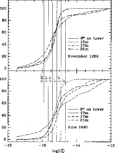
Microthermal sensor data from APO. Cumulative distributions for the refractive index structure coefficient Cn² for all nights in November 1989 and June 1990 measured at at the four levels on the tower (9.2,12.6,16.8,and 21.2m) are shown. The vertical bars labeled with the FWHM seeing diameter are derived using an atmospheric model (Anderson and Morales 1991).

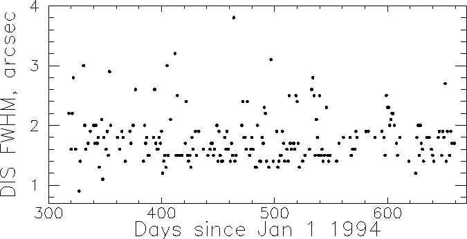
Image size at g measured by the Digital Image Spectrograph (DIS). The data were taken between November 1994 and October 1995.
All optical telescopes require clear, dark skies, but the operation of the SDSS further requires that about 25% of the clear time be photometric and have seeing <= 1" . The ARC telescopes have been located at APO because it fulfils these requirements. The National Solar Observatory, located at Sacramento Peak about half a mile from the APO site, ran nighttime seeing tests with the vacuum tower telescope during 1976 and 1977. The median seeing was 0.8 arcseconds and the seeing was better than 1 arcsecond 56% of the time (Beckers et al. 1979). The APO site should be even better than this, since it typically samples a more nearly undisturbed wind flow than does the Sacramento Peak site.

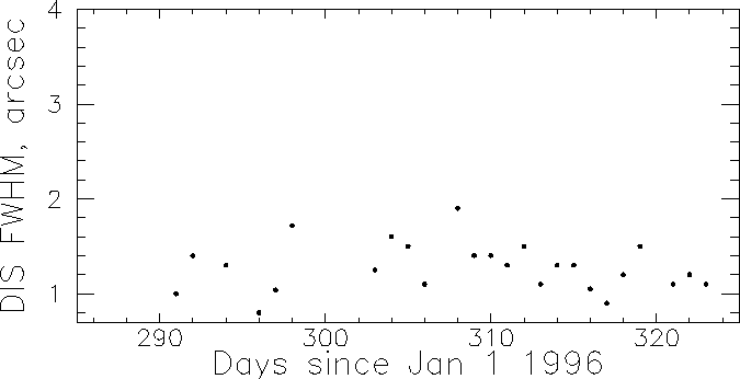
Image size at g measured by DIS between October and November 1996.
A weather tower was installed at APO in 1984 and has been in almost continuous operation since, under the direction of Kurt Anderson (New Mexico State University), the ARC site director. This tower is located on the ridge occupied by the 3.5 m and 2.5 m telescopes, about midway between them. The 23-m tower has microthermal sensors at heights of 9.2, 12.6, 16.8 and 21.4 meters above the ground. Each sensor consists of two coils of 40-micron nickel wire, separated by one vertical meter and connected in a bridge circuit. The resistance is temperature sensitive, and the measured temperature differences can be converted to differences in the index of refraction of the air at different levels, using the temperature and pressure of the ambient air, also measured at the tower. The mean-square differences of refractive index can then be converted to the index of refraction structure coefficient Cn² for Kolmogorov turbulence:

where h is a vertical vector to a layer of height h and r is a separation vector between two points.
With a vertical exponential scale length for the index variations and an atmospheric model (a plane-parallel, standard atmospheric model was used), the resulting structure coefficient is simply related to the Fried parameter, r0, (Roddier 1981) which in turn is related to angular image size theta : theta ~ lambda /r0 .
Eleven years of data are now available from this tower. Seeing effects at 1000 meters, measured by airplane flights in 1977 and 1978, can be combined with the tower measurements to yield the scale height of the index variations (Anderson and Morales 1991). The results can be summarized as follows: The seeing measured in this experiment has a median near 0.7 arcseconds, and is below 0.5 arcsecond 10-20% of the time, depending on the season. The microthermal tests show that the seeing is best in the winter months and worst in the late summer. Typical measurements for a month in November 1989 and another in June 1990 are shown in Figure 3.4. The interpretation of these data is not quite straightforward; one could simply average the values at different levels, or one could take the highest level as most representative of the atmosphere above the tower; the actual contribution to the integral of the values near the ground is small. In any case, the results are somewhat better, on average, than the direct measurements of Beckers et al. (1979), possibly because of his smaller database, possibly because his site is not quite so good, and certainly because his measuring resolution was only 0.5 arcsecond.
We are not yet able to confirm the expected good seeing performance from direct observations with the ARC 3.5 m telescope, which has been in operation for the past three years; the telescope optical system (particularly the secondary mirror optical figure) has not yet been optimized. The image size measured by the Digital Imaging Spectrograph (DIS), is shown for the period November 1994 - October 1995 in Figure 3.5, and for October - November 1996 in Figure 3.6. The image size measured by DIS in the last year (November 1995 - October 1996) has been below 1.5" 70% of the time, a big improvement.
Measurements of the optical figure of the telescope by C. Stubbs (1996) show that the telescope optical system contributes 0.6" while the large pixel size ( 0.8" ) of DIS contributes about 0.3" . The intrinsic seeing corresponding to an image size of 1.2" (Figure 3.6) is then about 0.7" . The median seeing at APO is thus less than 1" at visible wavelengths. Observations with ARC's low-resolution infrared spectrograph and imager (GRIM) yield a median seeing of 0.8" and have directly measured image sizes of < 1" 25% of the time in 1996. The 3.5 m data thus confirm that the seeing at APO is good enough enough of the clear time (25%) to carry out the SDSS.
In summary, the Apache Point site is characterized by mild weather, a very dark sky, a high incidence of clear skies, and topography which ensures that the seeing is excellent a large percentage of the time. Prior development of the site and proximity to the NSO make siting the survey telescope there much less expensive and more convenient than would be the case at any new site. The nature of the project makes it highly desirable that a continental U.S. site be chosen, and we doubt strongly that a better one exists for our purposes.
Anderson, K., and Morales, A., 1991, (private communication).
Beckers J.M., Breedlove W.O., DeMastus H.L., DeVegvar P.G.N., Johansen E.E., Gilliam L.B., Mann G.R., Mauter H.A., and Phillips G.L., PASP 91, 857, 1979.
Hull, C., Limmongkol, S., & Siegmund, W. 1994, Proc. S.P.I.E., 2199.
Roddier, F., 1981,Progress in Optics XIX, 281.
Schneeberger T.J., Worden S.P., and Beckers J.M., PASP 91, 530, 1979.
Smith, B. A. and Salisbury, J. W., 1962, Air Force Cambridge Laboratories Report 1064.
Stubbs, C.W. 1996, (private communication).